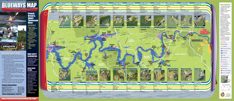
A blueway is essentially a water route, and Knoxville has some of the finest!
There are many river access points to the Tennessee, French Broad, and Holston rivers for paddlers and boat enthusiasts to enjoy.
The Great Smoky Mountains Regional Greenways Council and its partners created a Blueways Map showing put-in and take-out locations for paddlers from the Fort Loudon Dam to the Tennessee/North Carolina border of the Cherokee National Forest.
This map was created a few years ago, so there are some changes.
Click here for an updated list of these changes.
The WEST half of the map goes from Fort Loudon Dam to Volunteer Landing in downtown Knoxville. The EAST half of the map goes from Volunteer Landing in downtown Knoxville to Cherokee National Forest.
BLUEWAYS MAP WEST END - View larger map [PDF]
 This map covers these access points:
Carl Cowan Ramp
Cove Ramp
Cherokee Ramp
Choto Marina
Concord Marina
Concord Ramp
Duncan Marina
Fort Loudon Dam Marina
Fox Road Marina
Friendsville
I.C. King Ramp
International Harbor Marina
Lenoir City Park Ramp
Louisville Park Ramp
Marine Park
Maxey's Boat Dock
Poland Creek
PJ's Landing Marina
Sequoyah Put-In
Sequoyah Ramp
Volunteer Landing
Willow Point Marina
BLUEWAYS MAP EAST END -
View larger map [PDF]
 This map covers these access points:
Bridgeport Market
Cherokee National Forest Boat Ramp
Claussen Landing
Cruze Landing
Forks of the River
Gov. Ned McWherter Park
Highway 66
Highway 321
Holston River Park
Ijams Nature Center
Island Home Airport
Island Home Park
Leadvale
Mountain Cove Marina
Rankin Bridge
Sandbar
Seven Islands Wildlife Refuge
Tailwaters
Tent Camping USA
Volunteer Landing
Walters Bridge
Weaver Bend